DMCI Homes Township Central - "Your alternative way"

Welcome to Town Central, the true City of Tomorrow by DMCI Homes, an 100-hectare mixed-residential community of high-rise buildings, mid-rise structures and sprawling subdivisions.
Centrally located in the metropolis, in the progressive city of Taguig, Township Central will enjoy easy access to the major commercial and business hubs of Metro Manila—Makati, Ortigas and Bonifacio Global City. Its location is also conveniently the best schools, hospitals, and leisure centers, and is accessible via public transport. Within the property itself will rise an 8,000 square meter, two-storey commercial hub for the pleasure and entertainment of its residents and their guests. Also within the property will be a designated zone for schools, police and fire stations, and a community chapel.
Township Central is master planned to be DMCI Homes’ premier land bank on which will rise future homes, designed for specifically for your modern needs...Click below image to view map of Township Central
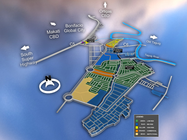
Click image to zoom
COMPETITIVE LANDSCAPE:
- TAGUIG CITY vs MAKATI CITY
- DMCI HOMES TOWNSHIP CENTRAL VS FORT BONIFACIO
Based on the latest competitive scan report, comparable projects in Taguig City were at 75% sales absorption (composed of Trion Towers, East Tower by Ayala Land, Seibu Tower by Golden Forum Land, The Fort Palm Spring by First Global, Fifth Avenue Residences by Robinson's Land, and Blue Sapphire by G&W Architects). Prices per square meter at The Fort, specifically runs from Php 70,000-90,000.00. Meanwhile, DMCI Homes products' price per square meter ranges from Php 45,000 60,000.00 Condominium and residential projects in BGC, including McKinley Hill are not comparably priced vs. Cedar Crest. These are mostly high-end projects with price per sqm ranging from Php 80,000 to Php 120,000 or almost twice the price of Cedar Crest per sqm.
Advantage of Taguig City in the Future:
- SM CITY MALL Taguig "Coming soon"....Click here for more info
- C-5 & C-6 Road Infrastructure
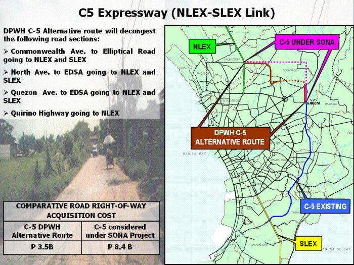
What is C-5 Road?
Circumferential Road 5, also known as C-5 (or C-5 Road) is a beltway which stretches from Taguig City to Quezon City in Metro Manila, the Philippines. It is one of five circumferential roads which surround the metropolis, running through the eastern portion of Metro Manila and effectively serving as a reliever road for Circumferential Road 4, better known as Epifanio de los Santos Avenue (EDSA).
C-5 as a whole is better known by four names: the Taguig and Makati portions as Carlos P. Garcia Avenue, the Pasig portion as E. Rodriguez Jr. Avenue, the Libis portion as Boni Serrano Avenue and the Loyola Heights portion as Katipunan Avenue. In addition, C-5 also has other names in addition to those used on the four major stretches of the road. However, when taken collectively, the entire road is called C-5.
Length:19.7 km (12.2 mi)
North end: Mac Arthur Highway in Valenzuela City (Existing)
Mariano Naval Street in Navotas City (Extension)
Beltway around Manila
Major junctions:
Coastal Road in Las Piñas City(Extension)
Major cities:
Circumferential Road 5, also known as C-5 (or C-5 Road) is a beltway which stretches from Taguig City to Quezon City in Metro Manila, the Philippines. It is one of five circumferential roads which surround the metropolis, running through the eastern portion of Metro Manila and effectively serving as a reliever road for Circumferential Road 4, better known as Epifanio de los Santos Avenue (EDSA).
C-5 as a whole is better known by four names: the Taguig and Makati portions as Carlos P. Garcia Avenue, the Pasig portion as E. Rodriguez Jr. Avenue, the Libis portion as Boni Serrano Avenue and the Loyola Heights portion as Katipunan Avenue. In addition, C-5 also has other names in addition to those used on the four major stretches of the road. However, when taken collectively, the entire road is called C-5.
Length:19.7 km (12.2 mi)
North end: Mac Arthur Highway in Valenzuela City (Existing)
Mariano Naval Street in Navotas City (Extension)
Beltway around Manila
Major junctions:
- South Luzon Expressway in Taguig City
- Kalayaan Avenue in Makati City
- Ortigas Avenue in Pasig City
- Boni Serrano
- P. Tuazon Blvd.
- Aurora Blvd.
- Commonwealth Avenue
- Visayas Ave.
- Mindanao Avenue
- Quirino Highway in Quezon City and
- Mac Arthur Highway in Valenzuela City(Existing Junctions)
- Commonwealth Avenue
- Qurino Highway and Mindanao Avenue Intersection in Quezon City
- North Luzon Expressway
- Mac Arthur Highway in Valenzuela City and Mariano Naval Street in Navotas City
- (North Extension)
- Ninoy Aquino Avenue in Parañaque City
- Quirino Avenue and Coastal Road in Las Piñas City (South Extension)
Coastal Road in Las Piñas City(Extension)
Major cities:
- Valenzuela City,
- Quezon City,
- Pasig City,
- Makati City,
- Parañaque City
- and Taguig City (Existing C-5 Road)
- Navotas City,
- Malabon City
- and Las Piñas City (C-5 Road Extension)
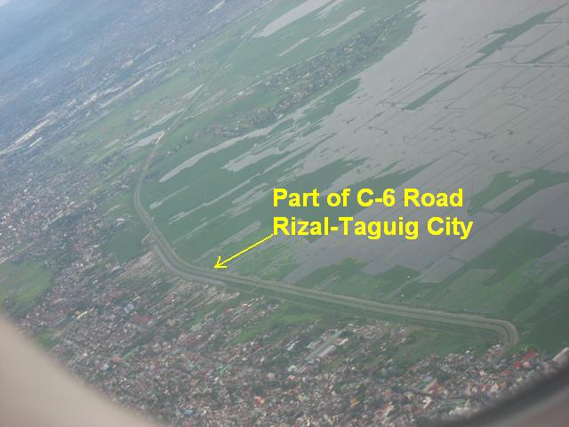
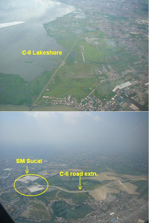
C-5 and C-6 Road Map & Actual photos (click image to zoom)
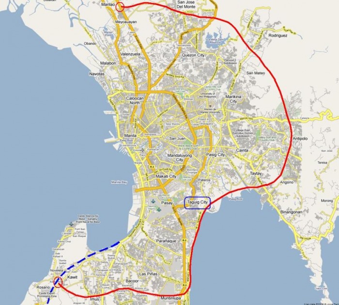
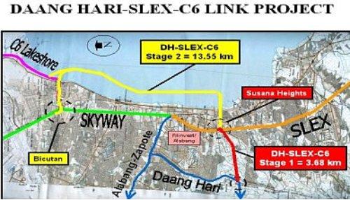
What C-6 Road? Also known as Circumferential Road 6
Bulacan-Rizal-Manila-Cavite Regional Expressway
When built, C-6 will follow the proposed Metro Manila Tollway route eastward starting from its terminus at the
- - North Luzon Expressway in Marilao in Bulacan province (Expressway segment). C-6 will then pass through
- - San Jose Del Monte City in Bulacan, turn southward and pass through
- - Montalban (also known as Rodriguez),
- - San Mateo,
- - Antipolo City,
- - Angono, and
- - Taytay in Rizal province, finally entering
- - Taguig City. The Metro Manila Tollway will continue southwest to the
- - South Luzon Expressway ending near the
- - Bicutan interchange. C-6 will continue southward
- -along the proposed Laguna de Bay Coastal Road running along the coast of the Laguna de Bay into Muntinlupa City. It will eventually pass the
- - Alabang district of Muntinlupa City. In Cavite, it will pass
- - Bacoor,
- - Imus,
- - Kawit,
- - Noveleta, and
- - Cavite City. It will eventually
- - connect R-1.
This expressway is also known as Circumferential Road 6 (C-6). It starts at McArthur Highway near SM City Marilao in Marilao and ends at Cavite City just near the Cavite City View of Manila Bay with a T-Intersection.
List of Exits:
These are the list of exits of Bulacan-Rizal-Manila-Cavite Regional Expressway and it starts at Exit 5 because the MacArthur Highway-NLEX Segment is not part of the expressway unlike US Freeways. Rizal Park is designated as Kilometer Zero (Km 0).
- Kilometer 5 (Southbound) - Marilao Toll Plaza - Lias, Marilao, Bulacan
- Exit 6 - NLE - P. Zamora Interchange - Marilao, Bulacan
- Exit 7 - Francisco Homes Interchange - Francisco Homes, San Jose del Monte City, Bulacan
- This exit takes San Jose del Monte-Bocaue Road. This is an alternate route to Santa Maria, Bocaue, Francisco Homes, and other parts of Bulacan.
- Exit 10 - Bigte Exit - Bigte, San Jose del Monte City, Bulacan
- This exit takes Manila-del Monte-Garay Road, the extension of Quirino Highway. This exit is an alternate route to Norzagaray, Doñna Remedios Trinidad, and other parts of Bulacan and it is the alternate route to Novaliches, Quezon City and Caloocan City (N).
- Exit 13 - Rodriguez Exit - Rodriguez, Rizal
- Exit 14 - San Mateo Exit - San Mateo, Rizal
- Exit 17 - Antipolo Exit - Antipolo City, Rizal -This road takes Marcos Highway. This is the alternate route to Quezon City, Marikina City, Quezon province, and other parts of Rizal province.
- Exit 18 - Ortigas Exit - Ortigas Avenue Extension, Antipolo City, Rizal - This exit is only situated for vehicles going to Cavite only. No exit of Ortigas going to Marilao. This exit is an alternate route to Ortigas Center in Mandaluyong City and Pasig City, Cainta, and other parts of Rizal.
- Exit 20 - Angono Exit - Angono, Rizal
- Exit 22 - Taytay Exit - Taytay, Rizal - This exit can take Manila East Road. It can go to SM City Taytay.
- Exit 29 - Taguig Exit - Taguig City
- Exit 31 - Brittany Bay Exit - Brittany Bay Subdivision, Sucat, Muntinlupa City
- Exit 34 - Alabang Exit - Filinvest Corporate City, Alabang, Muntinlupa City This exit can take to Soldier's Hills, Pleasant Village, Alabang, and Las Pinas City.
- Exit 35 - Susana Heights Exit - Tunasan, Muntinlupa City- This exit can go to South Luzon Expressway by taking the Everest Hills Service Road.
- Exit 38 - Molino Exit - Molino 2, Bacoor, Cavite - This exit can take Molino Road. It is near SM Supercenter Molino.
- Exit 39 - Bacoor Exit - Bacoor, Cavite - This exit can go to Aguinaldo Highway (R-1). This exit is an alternate route to Imus, Dasmariñas, Silang, Tagaytay City, Laguna province, Batangas, Las Piñas City, Ninoy Aquino International Airport, Parañaque City, Pasay City, and Manila.
- Exit 42 - Imus Exit - Imus, Cavite
- Exit 43 - Kawit Exit - Kawit, Cavite - This exit can take to Aguinaldo Shrine.
- Exit 45 - Noveleta Exit - Noveleta, Cavite - This exit is an alternate route to Naic, Maragondon, Tagaytay City and other parts of Cavite. The exit can go to NORTH and SOUTH Reclamation Areas. This exit takes to Las Piñas-Noveleta Road.
- Exit 46 - Manila-Cavite Expressway-BRMCREx - Noveleta, Cavite
- Kilometer 47 (Northbound) - Cavite City Toll Barrier - Cavite City, Cavite
- Exit 48 - Cavite City Exit - Cavite City, Cavite
Additional Inputs:
The proposed alignment for MMT C-6 will start from the proposed Manila South Skyway (MSS) at the vicinity of the Bicutan Interchange, will run eastward by viaduct over the existing Gen. Santos Avenue towards Laguna de Bay. On the lake shore, the line, on earth embankment, will veer north following the shoreline, then northeast passing through Tagig, where it will move inland at-grade in a northeasterly course towards Taytay, then northward through Antipolo and San Mateo. Thereafter, the line will shift in a northwesterly direction, then westward through Quezon City, Caloocan City and will end at the MNE in Meycauayan.
The alignment will have a total length of 47.5 kms, consisting of the following road sections:
- Viaduct sections - 5.18 kms
- Fill sections, lakeshore (water) - 2.38 kms
- Fill sections, land - 11.90 kms
- Cut and fill sections - 26.91 kms
- Bridges and other structures - 1.09 kms
- Segment 1 – MSS/Bicutan to Imelda Ave. Ext. - 8.3 kms
- Segment 2 – Imelda Ave Ext. to Ortigas Ave. - 7.4 kms
- Segment 3 – Ortigas Ave to Marcos Hwy - 5.6 kms
- Segment 4 – Marcos Hwy to JP Rizal Street - 7.5 kms
- Segment 5 – JP Rizal St to Commonwealth Ave. - 5.6 kms
- Segment 6 – Commonwealth Ave to Quirino Hwy - 5.3 kms
- Segment 7 – Quirino Hwy to MNE/Meycauayan - 7.8 kms
Total Length of MMT C6 - 47.5 kms kms
ENGINEERING ASPECTS
• • Existing Road Sections Along the Proposed MMT C6
- A 2-km stretch of Gen. Santos Avenue from the Bicutan Interchange to the shoreline of Laguna de Bay. A viaduct over the avenue is proposed.
- A portion of Highway 313 (Manila East Road) from its intersection with Rodriguez Avenue (Highway 21) south of Taytay to Ortigas Avenue, about 2.4 kms long. Widening of the stretch and provision of service roads for local traffic are proposed.
- A 2-km portion of Commonwealth Avenue within the Fairview Park Subdivision in Quezon City. A viaduct over the stretch is proposed.
- A 3-km stretch of wide subdivision road through Bo. Lagro, Quezon City. It is proposed to acquire this section to be commissioned as part of the tollway, provide service roads on both sides and install a flyover to connect both sides of the subdivision.
1. Updating of Feasibility Study Dec '08 - Feb '09
2. Project ProposalApproval Mar '09 - Apr '09
3. DPWH Bidding May '09 - Sep '09
4. TCA Approval Oct 2009
5. Detailed Engineering Design Nov '09 - Oct '10
6. Right-of-Way Acquisition Jun '10 - Dec '11
7. Construction Jan '11 - Dec '13
8. Tollway Operation and Maintenance Jan '14 - Dec '44
BACK TO DMCI HOMES property listings in Taguig City
